Autore: Theodore White
Data di pubblicazione: 13 Settembre 2016
Fonte originale: https://www.facebook.com/theodore.white1/posts/10154498701939872
Riassunto e Traduzione: Sara Maria Maestroni
“Raffreddamento globale”, 2017-2053, Theodore White.
Voli aerei di linea e aumento delle turbolenze in quota
 L’articolo ha come obiettivo quello di mettere in relazione la fase di raffreddamento a cui sta andando incontro il clima e le frequenti e severe turbolenze riportate da diversi piloti in questi ultimi anni.
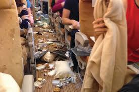
L’ultimo episodio è avvenuto il 31.08.2016 quando un Boeing 767-300, in volo da Houston a Londra, ha dovuto fare un atterraggio di emergenza a Shannon (Irlanda), poiché 23 passeggeri si sono feriti durante una massiccia turbolenza – secondo i loro racconti, la turbolenza è stata tale per cui le cose volavano per la cabina e i passeggeri non legati hanno colpito il soffitto della cabina.


Questo tipo di turbolenza sta costando agli USA più di 500 milioni di Dollari all’anno.

L’autore dell’articolo spiega questi fenomeni sempre più frequenti con il cambiamento nel jet stream: in particolare, a 10-12 Km di altitudine (zona di volo per i jet moderni), si sta verificando da alcuni anni un cambiamento nella direzione dei venti di jet stream e delle temperature dell’atmosfera terrestre. Il tutto inserito in un quadro più ampio di globale raffreddamento.

Ciò che lui ravvede è un cambiamento del jet stream, da un pattern di flusso zonale ad uno meridiano – si crea così una turbolenza.
 I piloti però, mentre volano, non hanno parametri che li possano avvisare della turbolenza in arrivo e quindi l’aereo ci si trova in mezzo all’improvviso.
Sempre secondo l’autore, questi episodi sono in aumento per via del raffreddamento globale, legato al calo dell’attività solare e all’alterazione del jet stream.
Porta l’esempio di come anche il pattern di oscillazione quasi-biennali si stia modificando.
In particolare, i venti equatoriali eastward e westward si sono sempre alternati ogni 28-29 mesi, risultando quindi facilmente prevedibili. Sembra che questo non lo sarà più.
Tutto ciò è dovuto al cambiamento nell’attività solare che influenza l’atmosfera più alta della stratopausa che si è riscaldata a causa dell’aria polare forzata a migrare a sud dallo slittamento del jet stream nell’emisfero nord.
A seguito del cambiamento nel jet stream visto prima, aria densa e fredda dalle alte latitudini è forzata nell’atmosfera piena di umidità della tropopaussa e alle medie latitudini, dove la maggior parte delle persone vive.
Di conseguenza, secondo l’autore, tutto il discorso sul riscaldamento globale legato all’attività umana è una stupidata – silly thing – e chi lo afferma non ha idea di cosa sta succedendo nel mondo.
Cosa sta succedendo – si chiede l’autore?
Il Sole sta entrando in una fase di quiescenza – il Grande Minimo – con una notevole riduzione delle macchie solari – “blank Sun”.
Il calo del riscaldamento della stratopausa terrestre vede le temperature arrivare vicino al congelamento – ecco perché, spiega, l’artico si stava riscaldando, non per l’attività umana.
In questo modo, l’umidità evapora e cade fuori dalla sua zona di reazione.
 Tale umidità viene super raffreddata nell’atmosfera polare e i cristalli che si formano assumono una forma esagonale – diamond dust. Tali cristalli sono altamente riflettenti e rifraggono la luce solare come un prisma.
Tali cristalli sono molto leggeri e possono galleggiare per mesi, provocando la formazione di aria densa e fredda sotto di loro.
A causa del calo dell’attività solare, quest’area dell’atmosfera si sta riducendo.
L’autore conclude l’articolo, specificando che l’assetto meridiano del jet stream diventerà il motore principale dell’estrema variabilità e delle severe tempeste che caratterizzeranno l’era del raffreddamento globale.
Tutta questa variabilità renderà molto più difficile fare delle previsioni attendibili, anche nel breve termine.
Il tempo si svilupperà velocemente e porterà molte precipitazioni nevose e di pioggia, con venti più forti.
Tornando all’uso degli aeromobili, afferma che, secondo lui, viaggiare in aereo diventerà più pericoloso.
Lo staff di Attività Solare ringrazia Sara per il riassunto e la traduzione del testo.
Sono concetti che conosciamo e di cui parliamo da tempo. Questa testimonianza è, però, l’ennesima prova che il cambiamento è in atto.
Nel testo di Sara ci sono sicuramente alcuni passaggi che molti di voi stenteranno a comprendere…. uno fra tutti è perché, a seguito del Raffreddamento della stratosfera, l’aria calda dovrebbe scendere di quota. Sono meccanismi noti da tempo… Quando la stratosfera è fredda, a bassa quota è caldo. Quando la stratosfera si riscalda (statwarming), a bassa quota è freddo.
Purtroppo dal 1980 circa, la stratosfera si sta raffreddando molto in quanto la temperatura in tale zona, mediamente, tende a seguire l’andamento dell’Attività Solare con diversi mesi di ritardo rispetto ad essa. Questo comporta una notevole perdita di energia e quindi di “stabilità”… rendendo il Jet Stream molto “movimentato”… con numerosi e molto ampie Onde di Rossby. Queste, com’è noto, trasportano aria fredda dalle alte latitudini verso le medie latitudini… e, contemporaneamente, trasportano aria calda e umida verso le alte latitudini.

In questa carta del giorno 13 settrembre, sono visibili i venti in stratosfera, alla quota corrispondente a 250 hPa (circa 10.000 metri). Sono ben visibili le Onde di Rossby… in particolare quella sull’Atlantico che crea una profonda saccatura che dall’Islanda scende fino al Portogallo, una “contraria” che porta aria calda verso la Scandinavia, seguita da un’onda molto ampia sulla Russia e l’asia centrale. Dall’altro lato del mondo ne abbiamo una “positiva” sull’Oceano Pacifico ed una molto particolare sulla West Coast… che sta portando freddo sullo Yellowstone, come abbiamo letto questa mattina, e freddo anche nella zona nord della California (testimonianze dirette di nostri contatti).
Questo genere di oscillazioni, in un regime di Riscaldamento Globale, semplicemente non possono esistere!
Buona giornata
Bernardo Mattiucci
Qui di seguito il testo originale:
Global Cooling – 2017-2053
‘Airline Flights Experiencing More Extreme Turbulence
The Reasons Why’by Theodore White, astromet
This autumn I am preparing several years of climate & weather forecasts for farmers worldwide.
It’s a very busy time for me as I am working on 5-year forecasts as global cooling sets into gear in 2017.
For months now, I have been swamped with questions as to what is happening to the Earth’s climate as extreme weather and incidents continue to make headlines. I will answer that question in this post.
First, an explanation of a recent event that has been becoming more common:
Two weeks ago, on August 31, 2016, United Airlines Flight #880 was transporting more than 207 passengers on a transAtlantic flight from Houston, Texas to London’s Heathrow airport when it was suddenly battered by turbulence so severe that it threw some passengers not wearing their seatbelts up to the cabin’s ceiling.
The aircraft, a Boeing 767-300, had to make an emergency landing at Shannon airport, Ireland and injured passengers were taken to University Hospital, Limerick. Twenty-three people were injured and all the passengers said that it was a terrifying experience.
“We were flying along as smooth as can be and then were just slapped massively from the top as if someone had torpedoed us,” one passenger said.
Another passenger told NBC News, “Things flew all over the cabin and kitchen area. One attendant cracked the side of her head and was bleeding.”
The passenger added that his own shoulders were “really, really hurting from grabbing on to the arm rest during those altitude declines.”
Back in 2009, I forecasted that the jet streams of the Earth were shifting. In the United States alone it is estimated that sudden air turbulence costs more than $500+ million a year.
The transition to global cooling is the cause and it is not a surprise to me that air passenger flights would experience increased extreme turbulence.
At heights of around 10 to 12 kilometers (6-7 miles) which is a typical cruising altitude for modern passenger jets, the jet stream wind patterns and sudden temperature changes are the causes of what has been going on higher in the Earth’s atmosphere.
This major shift in atmospherics is part and parcel of the climate transition to global cooling that I have been forecasting as the normal patterns of the jet streams is changing from a zonal flow to a ‘meridional’ flow.
It is an unstable airflow that produces clear-air turbulence. Often, there are no visual clues to give pilots advanced warning – then suddenly an aircraft is jolted with considerable force.
Extreme turbulence of this severity is experienced increasingly because of the climate transition to global cooling caused by the activity of the Sun and the alteration of the Earth’s jet streams.
For instance, I am sure that climate scientists have been noticing the unusual pattern changes of the quasi-biennial oscillation.
On average, the equatorial eastward and westward winds alternate about every 28 to 29 months, so they have been easy to predict.
But not any longer.
The changes are caused by the activity of the Sun, which affects the upper atmosphere of the stratopause, which has been warming because polar air is being forced to migrate further south by the shifting of the jet streams in the northern hemisphere.
In the United States alone, the delays and disruptions from turbulence already cost more than $500 million a year – and all the reports show that incidents are becoming more frequent.
All the talk of human-emissions of carbon dioxide and ‘man-made global warming’ being the cause is simply silly, but shows just how little those who say such things know what is actually happening in the real world.
Many airlines worldwide are reporting a steady rise in turbulence.
The extreme turbulence is because the polar jet streams are changing from a ‘zonal’ pattern flow to ‘meridional’ pattern flow.
And this is exactly what I had predicted would happen as the climate transition to global cooling neared closer and closer.
These shifts in the jet streams from zonal to meridional flows also delivers all dense cold air from higher latitudes down to the moisture-filled atmosphere of the troposphere and into mid-latitudes.
It is going to increasingly become the main driver of severe weather, extreme turbulence and violent storms in the new climate regime of global cooling.
‘WHAT IS HAPPENING?’
As the Sun settles into its quiescent phase, or its Grand Minimum there is a deep reduction in sunspots, revealing a ‘blank Sun.’
Now, because of this, the ultraviolet (UV) radiation that the Sun plummets.
The decline of heating of the Earth’s stratopause, its upper atmosphere sees temperatures there rise above freezing. (This is why the arctic has been warming, not because of ‘man-made global warming.)
Within the stratopause, temperatures rise and so all the frozen moisture evaporates then falls outside its reaction zone.
The moisture is super cooled to a level where ice crystals called ‘diamond dust’ forms in the polar atmosphere.
Diamond dust are microscopic ice crystals shaped in the form of hexagons.
The ice crystals are highly reflective and refracts sunlight like a prism.
Because diamond dust is super-light, these ice crystals can stay afloat for months in the atmosphere as pockets of very cold and dense air develop underneath them.
Diamond dust causes major temperature gradients which fuels the polar vortex to isolate and lock extremely cold air to the polar regions of the Earth.
However, as the Sun’s output weakens, and its ultraviolet radiation declines, the area in the high atmosphere where diamond dust forms in the stratopause also declines and shrinks.
So these ice crystals, along with all that cold dense air circulating inside the polar region diminish, and the Arctic warms up as the polar vortex deforms.
It allows the dense cold air to migrate, further south, and into the lower moist atmosphere and mid-latitudes – where the majority of the Earth’s population lives.
The Sun’s weakening state causes the polar jet streams to change from a ‘zonal’ pattern flow to a ‘meridional’ flow.
A meridional pattern jet flow has sharper edges with more vorticity and is responsible for altering the jet stream patterns.
The extreme turbulence is a result of the altered jet stream, especially in the northern hemisphere.
The meridional flow also causes blocking ridges that delivers colder air and temperatures; along with heavy snowfall.
This meridional pattern is going to become the primary driver of extreme turbulence and severe weather systems of blasting storms during the era of global cooling.
It is going to become much more difficult for conventional forecasters to predict the weather even in the short-range with the meridional pattern flows.
The weather will develop quickly and deliver more precipitation of rain and snow, along with higher winds and above-and-below average temperatures than in a zonal pattern.
I am used to medium and long-range advanced forecasting based on the changes to the jet streams however, because once you know what the climate conditions are, then it is a simple matter to forecast its resulting weather.
Those flying should be aware that air travel is going to become more dangerous because of the shift of the jet streams to a more pronounced meridional wind flow at sharp angles.
This meridional flow which also will deliver more strong storms in the new era of global cooling that begins in 2017.